Indian satellites are basically classified into 2 types
1. Geo-Stationary Satellites
2. Earth Observing Satellites
About Geo-Stationary Satellites
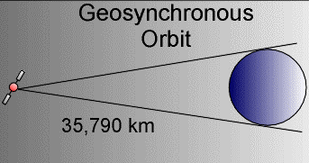
- Also known as geostationary orbits, satellites in these orbits circle the Earth at the same rate as the Earth spins. The Earth actually takes 23 hours, 56 minutes, and 4.09 seconds to make one full revolution. So based on Kepler's Laws of Planetary Motion, this would put the satellite at approximately 35,790 km above the Earth. The satellites are located near the equator since at this latitude, there is a constant force of gravity from all directions. At other latitudes, the bulge at the center of the Earth would pull on the satellite.
- Geosynchronous orbits allow the satellite to observe almost a full hemisphere of the Earth. These satellites are used to study large scale phenomenon such as hurricanes, or cyclones. These orbits are also used for telecommunication satellites.
- The disadvantages are since these satellites are very far away, they have poor resolution and have trouble monitoring activities near the poles.
- The orbital radius required for a geostationary orbit is 42,300km. Since the radius of the Earth is 6378 km the height of the geostationary orbit above the Earth's surface is 35,790 km.
- Examples - GSAT-12,GSAT-8.
About Earth Observing Satellites
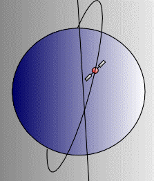
- Indian Earth Observing Satellites, known as Indian Remote Sensing Satellites,use Polar Sun Synchronous Orbits.
- These satellites orbit at an altitude between 650 to 800 km.
- Normally the number of Orbits per day is 14 with a repetivity of 24 days.
- The polar orbit remains fixed in space as Earth rotates inside the orbit. As a result, much of Earth passes under a satellite in a polar orbit. Because polar orbits achieve excellent coverage of the planet, they are often used for satellites that do mapping and photography.
- Examples - Resoursesat-2,Resoursesat-1.


0 comments: